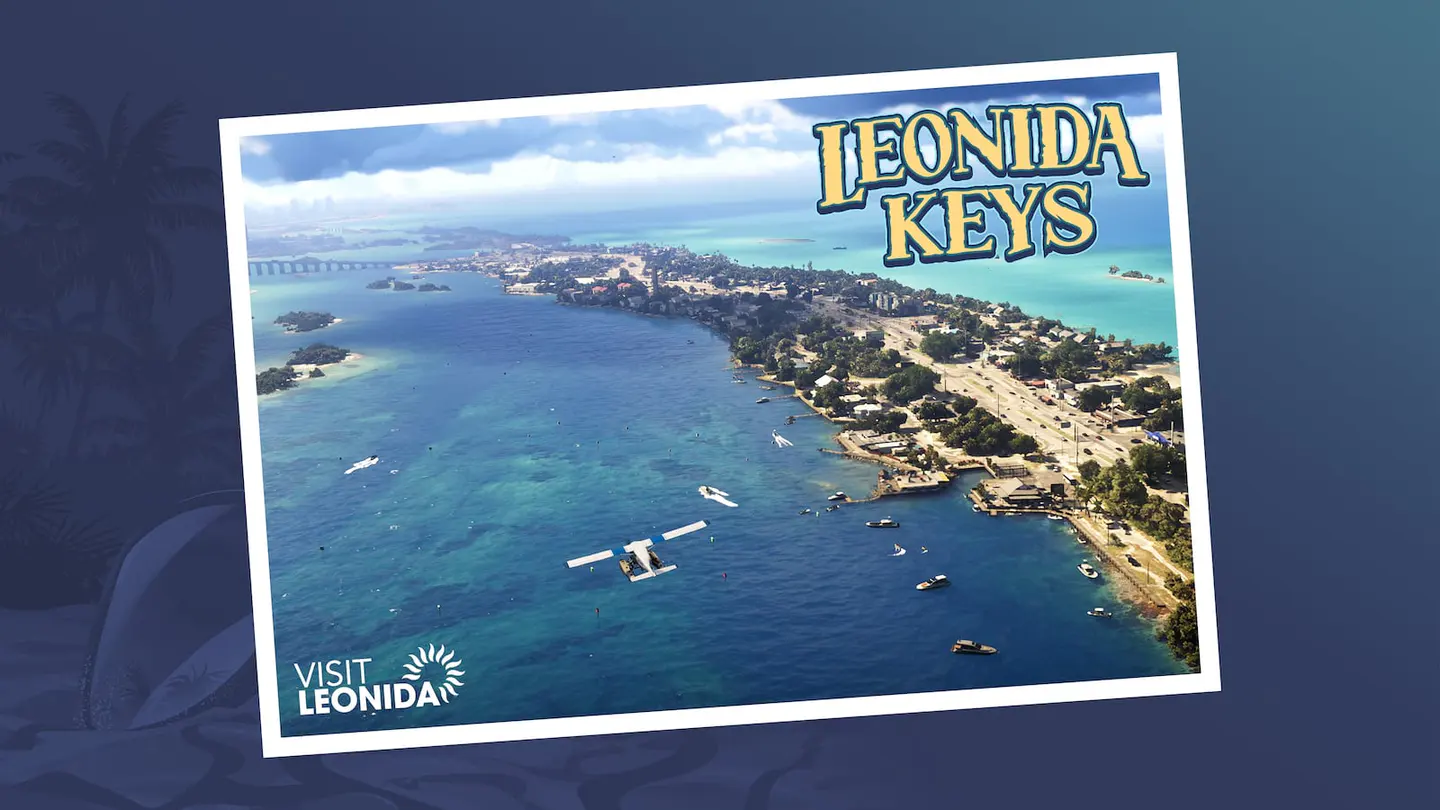
The GTA VI map has become its own parallel game years before launch. Fans have compared highways, coastlines, skylines, bridges, road signs, mountains, trailer camera angles and even the direction of sunlight to reconstruct Leonida piece by piece. Some of that work is remarkably disciplined. None of it turns into an official map simply because the pieces fit beautifully. Rockstar has named major regions and shown enough geography to prove GTA VI stretches far beyond Vice City. The exact road network, scale and final world boundary remain open.
Vice City is the center of gravity, not the whole state
Rockstar’s marketing naturally leans on Vice City because it is the name everyone recognizes. The beaches, high-rises, nightlife and neon give GTA VI an immediate identity. But the official site repeatedly frames the game around Leonida as a state, not one city. Jason and Lucia’s story is described as stretching across that state, and Rockstar has published locations that look radically different from the urban core.
The Leonida Keys are officially confirmed
The Keys bring water, bridges, islands, marinas and a slower coastal rhythm into the world. Jason’s official background is tied closely to this area, where he has been working around local drug runners. That makes the Keys more than scenic variety; they appear woven into the story and into the social world around Jason before the main plot accelerates.
Grassrivers gives the map a swamp ecosystem
Rockstar’s official location material presents Grassrivers as a wetland environment far removed from downtown Vice City. Swamps matter because they change how a world moves. Roads become more limited, boats become more useful, visibility changes and wildlife can shape the atmosphere. Even without knowing the exact gameplay systems, the region tells us Leonida is designed around distinct geographic identities rather than one continuous urban texture.
Port Gellhorn adds a rougher coastal city
Port Gellhorn appears to represent a more worn-down side of Leonida — motels, liquor stores, tourist remnants and a grittier local economy. Its value to the map is contrast. A second urban area does not need to compete with Vice City in size to make the state feel broader. It only needs its own rhythm, architecture and stories.
Ambrosia pulls the world inland
Ambrosia is officially presented around industry and local power rather than beaches. That shift matters because a convincing state needs economic geography as much as scenery. Factories, agriculture, logistics and working towns create reasons for highways and characters to exist between the glamorous areas. A world becomes believable when its roads seem to connect places that need each other.
Mount Kalaga pushes Leonida vertically
Mount Kalaga National Park is one of the most interesting official confirmations because it breaks the flat-Florida expectation. Rockstar’s version of Leonida is fictional, and the national park gives it room for elevation, wilderness, trails and a completely different horizon. It also destroys the idea that GTA VI’s entire world can be understood by measuring Miami and the Keys against real-world Florida.
Community reconstruction is analysis, not fantasy
The best mapping communities do more than draw guesses. They identify repeated landmarks, compare road curvature, triangulate skylines and revise placements when new official media contradicts an older assumption. That process can produce a useful working model of the world. The value comes from transparency: a good community map tells you which placements are strong, which are approximate and which are speculative.
Why exact square-mile claims are weak before release
Perspective makes scale deceptive. A road shown with a long lens can appear compressed. Trailer edits can jump enormous distances. Development can move coastlines or reshape roads. Even if fans place every visible landmark correctly, they still cannot see every inaccessible buffer, mission-only space or final world boundary. That is why a confident “GTA VI is exactly X times bigger than GTA V” headline is usually stronger than the evidence.
Map size is not the metric that will decide whether Leonida feels huge
Density can matter more than area. If Vice City has deep interiors, crowded streets, reactive businesses and layered activities, a relatively compact zone can consume hours. If the highways between regions are filled with encounters and distinct communities, the state can feel enormous without needing record-breaking dimensions. Rockstar’s official material suggests variety; the Extended Look may begin to reveal density.
What the August 27 Extended Look clarified
A sustained drive is more valuable than another overhead tease. If Rockstar lets the camera stay with the player while moving from one environment into another, we can learn about transition distances, road density, traffic, terrain and how the world changes outside a montage. A minimap or world-map glimpse would obviously be huge, but the geography can reveal itself through ordinary movement too.
How to use the community map without turning it into a Rockstar map
We officially know Leonida contains Vice City, the Leonida Keys, Grassrivers, Port Gellhorn, Ambrosia and Mount Kalaga National Park. Community mappers have built increasingly sophisticated reconstructions around Rockstar’s media, but there is still no complete official street map or authoritative square-mile figure. Use the fan map as a living hypothesis. Use Rockstar’s named regions as fact.
The official gallery now has 99 screenshots: more geographic evidence, not an official map
Rockstar’s screenshot page currently lists 99 images, and independent gallery comparisons identify 29 additions. That gives mapping projects more official views of Vice City, the Leonida Keys, Port Gellhorn, Grassrivers, Ambrosia and Mount Kalaga National Park.
The verification rule does not change. An official screenshot proves the visible scene and, when Rockstar labels it, the named location. It does not publish coordinates or final world boundaries. Community reconstruction can become better informed without becoming Rockstar’s map.
Sources reviewed
Primary material leads when it exists. Independent reporting and analysis are listed separately so you can inspect the evidence chain instead of trusting a single link.